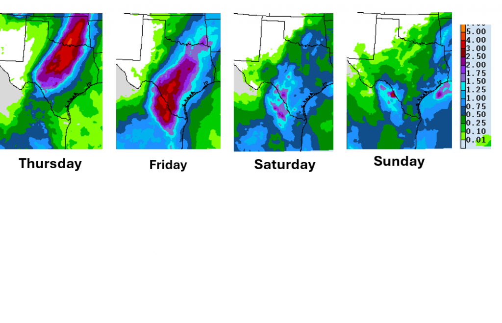
Moderate to heavy rainfall is forecast to develop across the Texas Hill Country beginning late Wednesday and continuing through Friday, with total accumulations that could average between 4 and 7 inches across the region, according to an LCRA weather outlook published Monday.
LCRA forecasters say the rain potential is tied to two converging weather systems. Major Pacific Hurricane Polo is expected to make landfall along the Baja California coast Monday evening and along the northwestern Mexican mainland Tuesday morning, according to LCRA. Polo's remnant moisture is then forecast to merge with an approaching Pacific trough as it moves across the southern Plains, contributing to the heavy rain threat for Texas. Both the landfall timing and the remnant-trough interaction represent multi-day forecasts and carry significant uncertainty.
A Pacific cold front is forecast to move into West Texas on Wednesday, October 1, then push east to the Hill Country on Thursday and reach the Interstate 35 corridor late Thursday into Thursday night, LCRA says. The agency notes that confidence in the front's timing is not particularly high and that it could move more slowly than currently predicted.
LCRA forecasts a southwest-to-northeast band of moderate to heavy rain developing Wednesday night across the Edwards Plateau, spreading east across the Hill Country on Thursday. The rain is expected to reach the Austin and I-35 corridor late Thursday, with the area from La Grange to the coast seeing rain Thursday night into Friday morning.
The Storm Prediction Center has placed West Texas and the northern Hill Country under a Marginal to Slight Risk for severe thunderstorms on Wednesday, according to LCRA. Large hail and damaging winds are identified as the primary threats for storms tracking across those areas.
Before the wet weather arrives, Monday afternoon through Tuesday night is expected to remain generally dry, with high temperatures in the mid and upper 90s. Southerly winds are forecast to increase to 10 to 15 miles per hour with occasional gusts to 25 miles per hour on Tuesday, according to LCRA.
Behind the front, LCRA forecasts slightly cooler conditions through the weekend, with highs in the low to mid-80s and overnight lows in the upper 60s to low 70s. Mostly sunny and dry weather is expected to return next week, with highs in the mid to upper 80s. The NWS rainfall forecast referenced by LCRA is valid through 6 p.m. Monday, October 5.
Residents in Bandera, Bexar, Blanco, Burnet, Comal, Edwards, Gillespie, Hays, Kendall, Kerr, Kimble, Llano, Mason, Real, and Travis counties should monitor updated forecasts at weather.gov as the storm system develops.
via LCRA. Originally published at LCRA.